


Finished! Looks like this project is out of data at the moment!
We've finally run out of data, and together you've rescued 50 years of tide gauge data in just over one year. Thanks for all your help!
FAQ
What is sea level height?
To measure the height of something, we need to measure the distance between two points: the top of whatever we are measuring, and some baseline, known as a datum. Often, this is obvious: when we measure our own heights, we measure the distance from the ground to the top of our head. However, other cases are more complicated: for example the height of a mountain is usually measured as a height above a national datum (for example, in mainland Great Britain, Ordnance Datum Newlyn, or ODN), which is based on average sea level. When measuring the height of the sea itself in a location, the choice of datum is somewhat arbitrary. However, to make sure it stays at the same height over time, we must link it to a physical object, usually a benchmark.
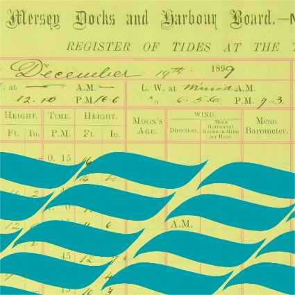
In the case of the data from Liverpool, heights were measured relative the Old Dock Sill (often referred to as ODS), which was the bottom of the entrance to the original Old Dock in Liverpool, built in 1715, and the first commercial wet dock in the world. It was clearly important for mariners to know the depth of the water over the sill when entering or leaving the dock, so the height became the working datum for dock area. When the Old Dock was closed in 1826 the datum continued to be used, and was transferred to the various other docks in Liverpool using levelling surveys.
 |
Canning Island tide gauge constructed in 1845 which provides a benchmark commemorating the level of the Old Dock Sill (Photo from Woodworth, 1999) |
What units were used?
Heights were measured in imperial feet and inches. For those unfamiliar with these units, 1 inch is 25.4 millimetres and there are 12 inches in a foot. Common abbreviations for the foot are ft or ' and for the inch are in or ".
When entering values, don't worry about including the units, just enter the two values with a space between them. Our software will convert that text to a height in metres.
What do the positive and negative signs represent?
The recorded sea level became negative when it fell below the height of the Old Dock Sill. However, rather than record all of these values using negative signs, the transcribers of the ledgers just put + and - signs on the entries either side of values becoming negative (or positive). In some older ledgers, the words 'above' and 'below' were written instead.
When entering values, just include the + or - sign after the height when it appears: our software will then identify the periods of negative data and adjust the heights accordingly. If the words 'above' or 'below' appear, replace them with + or - respectively.

What should I do if I can't read the numbers?
Each value will be entered by several volunteers, so if you're uncertain what a particular number is make your best guess, as we'll be able to compare it with what other people have entered. It can often help to have a look around the whole sheet for clues - as tides rise and fall fairly smoothly the values in the feet columns also change slowly, so try and find the problematic number somewhere else in the feet column and see what values go before and after it.
If the number is unreadable, or it is damaged or obscured, leave the box blank.
What should I do if there's no data for a given time?
Leave the box blank.
What should I do if there's other text in those boxes?
Sometimes the transcriber will have added some extra information, for example indicating if the gauge has had a fault. In these cases just enter the numbers: we'll be carrying out a full quality control of the data afterwards. However, feel free to click 'Done & Talk' at the end of the process and leave a message about it on our talk boards.
What will be done with the data afterwards?
The data will be quality controlled, and archived at the British Oceanographic Data Centre (BODC). It will also be included in the GESLA global sea level dataset, and the Permanent Service for Mean Sea Level (PSMSL) dataset, where they will be available for general use. We will complete a tidal analysis of the George's Pier data.