


Finished! Looks like this project is out of data at the moment!
FAQ
Frequently Asked Questions
How can I help?
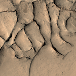
We are asking you to review images of the Martian mid-latitudes taken from orbit and to identify networks of ridges that intersect to make polygonal, spider-web-like patterns. These networks probably formed from the circulation of groundwater through the ancient Martian crust, resulting in mineral deposits along fractures. Wind erosion has eroded away the surrounding terrain, leaving the fractures standing in relief. With your identifications, we can map the locations of these polygonal ridges and try to figure out how they formed on Mars. The images you will be reviewing were taken with the Mars Reconnaissance Orbiter Context Imager (CTX). With any luck, some of the new interesting areas of Mars with polygonal ridges will get higher resolution imaging to further study these structures. Learn more on the About Page and the Field Guide.
Why can't computers do this?
Identifying polygonal ridges in black and white images is a task that currently computers are not good at, but it's a really easy task for the human brain. We're asking for your help so we can get a large sample of polygonal ridges so we can learn more about how they formed on Mars.
Why do you need so many people to help?
With 10 people reviewing each Planet Four: Ridges image, we can accurately determine whether polygonal ridges are present. By having multiple people independently assess each image, we gain the wisdom of the crowd. It has been shown that the combined assessment of many non-experts can often equal and outperform those of experts and automated routines.
Where do the images come from?
The images you see on Planet Four: Ridges come from the Context Camera (CTX) aboard Mars Reconnaissance Orbiter (MRO). The Context Camera takes wide view images (~30 km x ~60 km) of the Martian surface with a resolution of ~6 m per pixel, providing context for the higher resolution but smaller spatial coverage of MRO’s other instruments.
What part of Mars are we looking at?
The images you are reviewing are of the northern midlatitudes of Mars, just south of the equator. This region is known as Sinus Meridiani. We have previously looked for polygonal ridges in Arabia Terra, located around 30˚E longitude (the same latitudes as the United States on Earth).
How big of an area on Mars does each Planet Four: Ridges image cover?
We ask you to review 800x600 pixel subimages of CTX observations on the Planet Four: Ridges website. This corresponds to roughly a 4.8 km x 3.6 km patch on the surface of Mars.
Why is Mars black and white in these images?
The Context Camera does not have multiple filters and therefore cannot take color images. With one filter, the Context Camera images show up in grayscale.
What are you going to do with my classifications I provide?
Your classifications get stored in the Zooniverse's database. Later the Planet Four: Ridges science team will combine the multiple volunteer assessments for each image, including your classifications, to identify the polygonal ridge networks across Sinus Meridiani.
How do I know if I'm doing this right?
Human beings are really good at tasks like this, and generally your first answer is likely the right one. Multiple people review each image so chances are if you spot something in the image likely other people did too. Check out the Field Guide and the Help content for some more examples.
I made a mistake, can I go back and change my answer?
Once you have submitted your response for a given image, you can't go back and edit it. We combine the results from many people reviewing the same subject image. So don't worry too much about an occasional mistake.
I have a question or I found something interesting, who should I talk to?
You can make a post on our Talk discussion tool discussion tool. With Talk, you can discuss and interact with the rest the Planet Four: Ridges community including members of the science team. You can post a question in the Help or Chat board. You can also click the 'Done & Talk' button when classifying and post a comment and/or a hashtag to mark and describe the image you classified.
How do I keep up to date on the latest news about this project?
We will post updates on the Planet Four blog. You can also keep track of the latest news by following the Planet Four Twitter, Facebook, and Google+ accounts.