


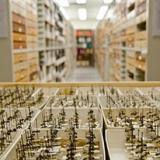
Finished! Looks like this project is out of data at the moment!
Thank you for your efforts! We've completed the classification stage for this project! To browse other active projects that still need your classifications, check out Notes from Nature.
FAQ
FAQs and Useful Tools
We have put together a list of frequently asked questions and useful tools related to transcribing records. These are based on discussion threads in the NfN discussion forums (linked at the bottom). Please take a look, and let us know if there are any questions we missed or useful tools that you can suggest. We really appreciate your input and all that you do for Notes from Nature. Thank You!
Common issues or questions:
1.) Interpretation and Misspelling: For drop down lists (eg. Country, State, County) please choose the correctly spelled entry. However, you should not make interpretations or corrections for open-ended fields and enter all information verbatim, including punctuation and spaces. This way, we can better achieve consensus when checking multiple records against one another (see below, on that process). You can bring misspellings to our attention using the Done & Talk feature.
2.) Missing information: When information is not given on the label, you should leave the field blank. Some information is easy to infer (for example, California is in the United States), and US counties can be found with a web search. We are not asking you to make this extra effort, but it is appreciated. However, if a search reveals multiple options for a field, please leave it blank.
3.) Extra information: If it is not clear where certain information belongs you can type it verbatim in the Other Notes field.
4.) Problem images: If you come across a problem record, like a faulty image or a record with illegible handwriting, you can flag the record by commenting on it and indicate what is in error (e.g. with the hashtag #blurry #illegible).
5.) Latitude and Longitude: Coordinates should be recorded in Latitude and Longitude fields respectively. Enter latitude and longitude values exactly as written. You can find symbols in Word or by searching online. You can also produce the degree symbol ° using key combinations (alt + 0 on a mac; alt + 0176 on a PC, with the keypad on the right side of your keyboard). Less common coordinate systems you may encounter include UTM (Universal Transverse Mercator) and TRS (Township-Range-Section).
6.) Elevation: Enter elevation verbatim (eg. 6600’, 5800ft, 2300m, 1200-1500m).
7.) Many collectors: Type name list verbatim, including punctuation. For our purposes, if there is no punctuation between collectors then you can add commas to separate the collector names.
8.) Inconsistent collector names: You will often find several variations of collector names (e.g. “Powell”, “J.Powell”, “J.A. Powell”, “JAP”). Please transcribe verbatim and do not assume it is the same person.
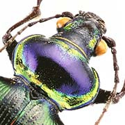
9.) Insect scientific name: The image may include an identification / determination (or det.) label for the insect. The scientific name typically includes a genus name (beginning with a capitalized letter) and a specific epithet (begins with a lowercase letter). An “sp.” or “spp.” indicates the species name is unknown. Please record the genus and species and subspecies if present. It may also include the name of the person who described the species, as well as the person who determined it to be that species. For example, for Cicindela californica subsp. pseudoerronea Rumpp; the genus is Cicindela, the species is californica and the subspecies is pseudoerronea. You should not include the person who described the species (also called author or authority), which in this case is Rumpp.
A full list of names can found on the Triplehorn Collection website for reference.
10.) Checking your transcription: You can use the Back button to the left of the Next button to check the information that you entered. Just click on any of the fields to make any necessary edits to your transcription.
11.) Barcode label: The barcode label should not be copied into the verbatim fields.
Some Useful Tools (discovered by NfN users)
Counties and Cities: Good tools for finding counties etc. are lists on wikipedia, there are lists of municipalities in each state of the USA (there are also similar lists for others). For example, https://en.wikipedia.org/wiki/List_of_municipalities_in_Florida (via the linkbox you can also change the state).
Mountains: https://en.wikipedia.org/wiki/Category:Lists_of_mountains_of_the_United_States
Uncertain Localities: GeoNames geographical database
Special symbols: You should be able to find symbols in word or by doing a google search and copy and paste. Here are a few:
– degree symbol for coordinates: °
– plus minus: ±
– fractions: ⅛ ¼ ⅓ ⅜ ½ ⅝ ⅔ ¾ ⅞
– non-English symbols: Ä ä å Å ð ë ğ Ñ ñ õ Ö ö Ü ü Ž ž