


Finished! Looks like this project is out of data at the moment!
Research
Welcome to Scars of War!
Join us in our search to uncover lost traces of World War II
Our mission
The aim of this project is to find structural military remains, such as bomb craters, trenches, and munition depots, hidden under dense vegetation cover. In recent years high-resolution elevation maps, created with a technique called LiDAR, have become widely available. The big advantage compared to many other measurement techniques is that LiDAR is not hampered by the presence of vegetation. This allows the investigation of areas in which archaeological remains are currently obscured by forest cover or other types of vegetation. Not all military structures have been recorded during or after the second world war. There are still scars of war hidden beneath the vegetation.
In this project, we investigate the Utrechtse Heuvelrug and the Gooi, a forested region in the central part of the Netherlands.

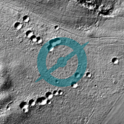
Research area on elevation map
What are LiDAR data?
LiDAR (Light Detection And Ranging) is a survey technique that measures the distance to a target by using a sensor that illuminates the target with pulsed laser light and subsequently registers the reflected pulses. The result is a 3-dimensional point cloud.
In recent years the surface of the Netherlands has been systematically measured with LiDAR sensors underneath airplanes (airborne LiDAR) resulting in a detailed elevation model of the entire country. This model, which is constantly updated, is made available for public use by Actueel Hoogtebestand Nederland (Current Dutch Elevation Model), the result of a collaboration between the Directorate-General for Public Works and Water Management, provinces, and water management agencies.
For the first time, these LiDAR data allow for the investigation of areas that are normally obscured by forest cover.

Traces from the past: what are we looking for?
The Second World War had a substantial impact on the landscape of this region. On the Grebbeberg near Rhenen, for example, heavy fighting took place during the first days of the war in May 1940. Several types of remains are clearly visible on the elevation map. These include bomb craters, trenches, shooting ranges, bunkers, foxholes, etc. In this project we will systematically search for bomb craters, trenches and munition depots. Other types of remains can be pointed out in the discussion section via keywords (#).
Citizen science and automated detection
In addition to discovering unknown examples of archaeological remains of conflict, this project aims to assist an innovative academic project that investigates the potential of combining citizen science and automated detection in archaeology. In this research project, the potential of using the results of multiple approaches, i.e., citizen science and automated detection (computer algorithms), to detect archaeology in LiDAR data is investigated. Therefore, the results of Scars of War are essential for this research project.

How can Zooniverse volunteers help?
The Gooi and Utrechtse Heuvelrug cover an area of >600 km2. This region is so large, that it becomes impractical (or even impossible) to analyze by a single or small group of professional archaeologists. Moreover, it has been widely attested in archaeological prospection that people's ability to identify specific features varies. In other words, people tend to have a bias for certain types of remains and systematically underidentify others. It is therefore important that several different people inspect every dataset and use the 'wisdom of the crowd' to obtain better results.
By registering as a volunteer you can start the search. Through the talk section, we will keep you informed about all activities and the first results of the project.

Collaboration
Scars of War is a collaboration between several partners who all aim to further elucidate the hidden military traces of this region and make the public aware of the scars of this period of conflict still present in the landscape.
- Landschap Erfgoed Utrecht
- Nationaal Park Utrechtse Heuvelrug
- Provincie Utrecht
- Steunpunt Monumenten en Archeologie Noord Holland
- vfonds
- Stichting Elise Mathilde fonds via
- Leiden University Fund
