


We have uploaded our second set of subjects! Check out our project update to learn more about the images you are seeing. Thank you for joining us!
Important note: Subjects from Workflow 1 (Yes/No) are routed into Workflow 2 (multiple choice). This means Workflow 2 may not always have images available. Please check back regularly to continue contributing to the multiple choice workflow. Thank you!
Research
Welcome to Kelp Quest!
Overview
Thank you for joining us — we’re excited to share the Seattle Aquarium’s research on the amazing kelp forests of Washington State!
We need the help of curious and caring people—like you—to conduct a benthic (seafloor) survey (Fig. 1). You’ll collect data on 28 distinct categories of kelp and other algae; mobile and sessile (immobile) invertebrates and fishes; and the underlying physical substrate.
Kelp forests are among the most productive and biodiverse ecosystems on Earth. They provide food, shelter and nursery habitats for countless species while also supporting coastal fisheries, protecting shorelines and enriching coastal communities. With the data we gather, we can conduct robust ecological analyses and build spatial habitat models that directly support kelp forest conservation, restoration and long-term management decisions. We make our data publicly available for the benefit of other conservation projects.
To collect the imagery you will review, we piloted a remotely operated vehicle (ROV) underwater at sites throughout Elliott Bay (offshore Seattle) and the San Juan Islands, Washington, U.S. Using downward-facing lights and cameras, we captured high-resolution photographs of the seafloor, one image every meter (3.28 feet), at an altitude (ROV height above the seafloor) of 0.8 meters (2.62 feet) (Fig. 1).

Fig. 1: Left: The Seattle Aquarium's Coastal Climate Resilience (CCR) team flying the ROV from a vessel in Elliott Bay. Right: ROV Lutris conducting a benthic survey offshore of Seattle, Washington, U.S.
To automate data extraction, we turned to the open-source, AI-powered software CoralNet-Toolbox (Pierce et al., 2025). CoralNet-Toolbox allows researchers to train ML models to recognize patterns in images—such as color, texture and shape—and use those patterns to predict what appears in new images.
Using CoralNet-Toolbox, we trained our model to examine small sections of our ROV images and predict which of 28 benthic categories appears at a specific point. From each image, we extracted 50 randomly distributed patches (Fig. 2a), each 224x224 pixels. These patches are the same “subjects” you see in this project.
Our ML model is still learning and does make mistakes. This is where you come in! By confirming or correcting the model’s predictions, you help improve its accuracy over time, which supports our ability to conduct and share this research.
For more information about the open-source ML model we use and how it works, please see the FAQ section.
- In Workflow 1: Yes/No, you’ll check whether the ML model’s text prediction matches what you see.
- In Workflow 2: Multiple Choice, you’ll tell us the correct category label.
Your contributions help turn underwater images into actionable science for kelp forest conservation.
Your support: uniform point contact
Uniform point contact is a widely used ecological survey method that allows scientists to measure what is living on the seafloor in a consistent, repeatable way. It is especially useful for organisms that grow in clusters or mats, like red algae and sugar kelp, where counting individuals is difficult. In these cases, scientists measure percent cover aka how much of the image area is occupied by each category.
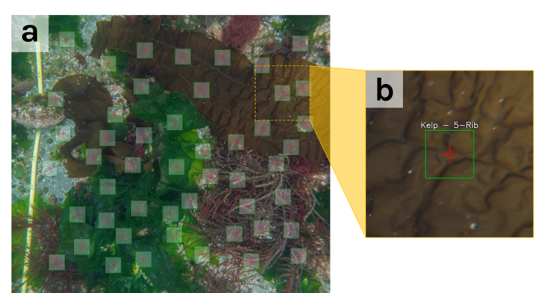
Fig. 2: a: ROV survey photograph with 50 randomly distributed percent-cover patches. b: a single percent-cover patch forms the core of a single Zooniverse subject that you will review.
For each Zooniverse subject (Fig. 2 b), you will see:
- A red crosshair with a red dot at the center (the exact sample point)
- A green box showing the 224 × 224-pixel image patch analyzed by our model
- The model’s predicted text label
- A small amount of the surrounding image for additional context
In both workflows, your task is to identify the category located directly under the red dot at the center of the crosshair. This is the point sampling in “uniform point contact.” You should identify what lies directly beneath the red dot, regardless of what else appears within the patch.
What you'll encounter
In Kelp Quest, you’ll help identify anything captured in our ROV imagery. Based on surveys in Elliott Bay and two sites in the San Juan Islands, we’ve distilled what appears in our images into 28 categories of kelp and other algae, seafloor substrate types, mobile and sessile animals, and a few special edge cases (Fig. 3).
We highly recommend reviewing the Field Guide, which describes each category, highlights key identifying features and explains common look-alikes and tricky situations.
Most of the points you classify will fall on algae or the substrate they grow on. You will sometimes encounter invertebrates or fishes, but these organisms are typically conspicuous, and we use a separate model to gather information about them. For this project, when the crosshair falls on an animal, you will assign it to the mobile species or sessile invert categories rather than identifying its species.
The naming convention used throughout Kelp Quest is "group - Category", with the group in plain text and the category Bolded. In instances where a group is comprised of a single category (e.g., Mobile species), the single label representing both group and category is Bolded.
Our groups are listed below, Fig. 3 depicts all 28 categories contained within our Field Guide.
-
Kelp: large brown algae in order Laminariales, including two general categories of Stipe, the "stem" structure of kelp, and Holdfast, the anchoring "root" structure that attaches algae to the seafloor.
-
Brown algae: three other non-kelp categories of brown algae, including the invasive Sargassum, also known as wireweed.
-
Red algae: spans diverse and visually distinct categories, including four fleshy red macroalgae and one encrusting coralline algae (CCA).
-
Green algae: one category Ulva aka sea lettuce, commonly found throughout our imagery.
-
Substrate: seven categories of seafloor that provide key information about the physical substrate our benthic species associate with.
-
Sessile invert: includes a large Other category for species captured via a different model and the visually distinct colonial Kelp bryozoan, which is well-suited for percent-cover data collection.
-
Mobile species: all mobile invertebrates and fishes.
-
Anthropogenic debris: a variety of human-related items, including plastics, bottles, tires, traffic cones, electronic scooters, etc.
-
Unknown: use when unable to determine a specific category (see below for a description of challenging scenarios).

Fig. 3: the 28 categories of algae, substrate, mobile and sessile species, and edge cases.
Troubleshooting challenges
Categorizing images won’t always be easy—and that’s part of why your work is so valuable!
Unlike tropical coral reefs, kelp forests thrive in cold, nutrient-rich conditions. These nutrients fuel plankton growth, which makes the water green and full of particles. Underwater visibility is often less than 4 meters (13 feet), making both ROV piloting and image interpretation challenging.
In addition, differences in ROV altitude (height above the seafloor) and seafloor terrain (flat, steep or uneven) can result in uneven illumination across an image, with some areas appearing darker or more washed out than others.
Other common challenges include:
- Edge distortion: Objects near the edge of an image may appear stretched, blurred or pixelated. (Fig. 4c, d)
- Seasonal change and decomposition: Some kelp species are annual, and algae decomposition may be visible, making identification more difficult.
- Similar-looking algae: Some categories closely resemble one another. For example, Sugar and Sieve kelp can look similar, as can red algae - Filamentous and brown algae - Filamentous.
- Similar substrates: Size-based categories, such as Pebble vs. Cobble or Sand vs. Silt, can be difficult to distinguish, particularly under low visibility or uneven lighting.
When deciding how to classify a challenging image:
- Use Unknown when the area under the red dot cannot be determined due to image limitations (e.g., too dark, blurry, obscured or affected by distortion).
- Use Not sure when the feature under the red dot is visible, but you cannot confidently decide which category it belongs to.
When in doubt, consult the Field Guide!

Fig. 4: Note the differences between the two leather stars (blue boxes) at the extremes of our field of view. Their colors and textures appear different, and camera distortion is evident in the deeper subject. Additionally, notice how sand is easily recognizable in the deeper portion of the image, but no features are discernible in the rightmost subject (red boxes). The rightmost subject demonstrates an appropriate use of the Unknown category.
With your help
Every subject you classify becomes part of a growing scientific dataset that helps us understand, protect and restore kelp forests in Washington State.
By contributing your time and attention, you are helping scientists:
- Improve machine learning tools that will accelerate future ecological research.
- Understand patterns of submerged vegetation and the physical substrates they grow on.
- Compare ROV-derived data with scuba diver surveys, helping researchers optimize subtidal monitoring programs.
- Detect the spread of invasive algae.
- Inform a habitat suitability model that can help guide bull kelp restoration planning in Washington State.
- Track ecological change across time and space, allowing researchers to investigate the drivers of kelp resilience.
These data support real conservation and management decisions, from identifying priority areas for bull kelp restoration to understanding how kelp forests respond to warming oceans and other environmental pressures.
You are also helping train the next generation of ecological monitoring tools. As our models improve, we can process imagery faster, expand monitoring efforts and respond more quickly to changes in coastal ecosystems.
Most importantly, your work helps turn underwater images into knowledge and knowledge into action for kelp forest conservation.
Acknowledgments
Advancing the Seattle Aquarium's research work is a team sport, and we could not do it without our collaborators, volunteers, and Aquarium colleagues. We deeply appreciate the hardworking team of volunteers who helped us generate a labeled dataset, including Abigail Chang, Cindy Gossett, David Muerdter and Barb Williams. We are grateful to the Port of Seattle, Habitat Strategic Initiative Lead, Washington Department of Fish and Wildlife, Washington Department of Natural Resources, Sea Otter Fund and Trust, Mission Blue, North Pacific Coast Marine Resources Committee, and Sustainable Path Foundation for their support. This project has been funded wholly or in part by the United States Environmental Protection Agency under assistance agreement PC-01J89501 through the Washington Department of Fish and Wildlife. The contents of this document do not necessarily reflect the views and policies of the Environmental Protection Agency or the Washington Department of Fish and Wildlife, nor does mention of trade names or commercial products constitute endorsement or recommendation for use.