


Finished! Looks like this project is out of data at the moment!
Thank you for your efforts! Our project is currently paused while we gather the next season of data! To browse other active projects that still need your classifications, check out zooniverse.org/projects
Research
Why Ducks?
We call the project "Drones for Ducks" because it's catchy, but it's not actually all about ducks. Ducks just happen to be the most common type of aquatic bird ("waterfowl") at the wildlife refuges we are studying. Migrating waterfowl in general are important not just to one ecosystem but to many as they make their seasonal journeys across vast landscapes, sometimes even between continents! Because of this, migratory waterfowl can provide a big-picture indication of environmental conditions. People also value waterfowl for other reasons: culture, aesthetics, or for hunting. People managing public lands like the National Wildlife Refuge System need to have accurate population counts so that they can ensure the habitat is suitable and has enough resources for all the birds, and to intervene if the population seems to be in trouble.
Counting Waterfowl
Traditionally, researchers count waterfowl out in the field, surveying either on the ground or from airplanes. The problem with both types of surveys is that they are imprecise and there is no way to go back and check the count later if there are any questions about it. Many species of waterfowl also get stressed out and may hide or flee when approached by humans on land, or by a loud, low-flying airplane.
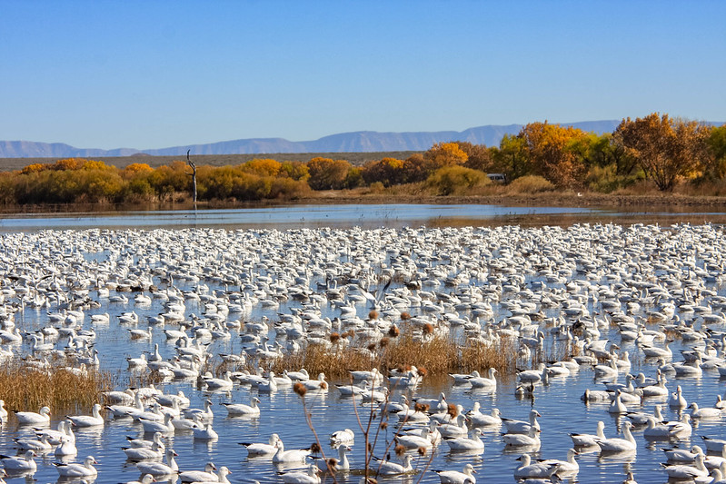
Drones and Wildlife Population Counts
Surveying waterfowl using drones equipped with high resolution cameras is a relatively new solution to these long-standing problems. The general method is to program a flight path for a drone that goes above a popular spot where waterfowl gather, and have it take pictures of the flock as it flies over. Drones are smaller and quieter than airplanes, so they can fly fairly low over flocks of waterfowl without stressing out the birds. They can also conduct a survey more quickly than humans can, over a much broader area. Back in the lab, researchers can count the birds more precisely from the images, and can reference these images if any questions arise later. The images also provide a wealth of contextual information (vegetation condition/type, water levels, climatic conditions, etc) that would be hard to replicate with surveys in the field.
Sounds great, right? However, there's a big drawback: the sheer number of images taken from the drones. It takes a lot of time to systematically go through all of the images to determine if there are any birds to be counted, not to mention to count the birds that are present.
Machine Learning
What if we could automatically scan an image and have a computer spit out the number and type of birds present? That is our goal! Right now, we are testing three different machine learning algorithms to determine which is the most accurate for detecting different types of birds in wetland environments in New Mexico. However, these algorithms need a lot of examples of what a "duck" or a "goose" looks like. Humans have to provide these examples to the computer; we call this training data. This is where Zooniverse users like you come in: you will be looking at images taken by drones and labeling all the birds you can see. These labels will then be given to the algorithms to teach them how to "find" birds automatically.