


Finished! Looks like this project is out of data at the moment!
Research
Welcome to Planet Four: Terrains!
The exotic terrains of the south polar region of Mars have many forms unlike anything on Earth. We would like your help to map where they occur. You will be looking for terrain types informally called “spiders”, “baby spiders”, “channel networks” and “swiss cheese”, and you will help us locate craters. The images you will analyze are from the Context Camera orbiting Mars – we will use the locations you identify as targets for higher resolution observations.
Scientists have noticed that spiders and channel networks are not uniformly distributed over the polar areas. Some locations seem fully covered with channels and others do not have them at all. The science team would like to know their distribution and try to figure out if it is correlated with properties of the soils or weather patterns.
How do spiders form?
Planetary scientists don’t know exactly how spiders form. But many believe that the same process is responsible for the creation of dark seasonal fans and blotches that have been spotted covering the south pole in the spring and summer.

Fans and blotches with spiders and channel networks. Image Credit:NASA/JPL-Caltech/Malin Space Science System
During the autumn a seasonal layer of carbon dioxide (CO2) ice, otherwise known as dry ice, forms on the southern pole. In the winter, this layer transforms into translucent slab ice. Once spring arrives, sunlight is able to penetrate and warm the ground below, causing the ice to sublimate (turn directly from ice into gas) from the bottom.
This sublimation causes gas to become trapped below the ice layer under increasing pressure. When a crack or a rupture develops, the gas bursts, not unlike a geyser, out of the opening, carrying along loose material eroded from the ground. When the gas and loose materials reach the surface of the ice, hey are often blown downwind of the vent, landing in fan-shaped deposits. If there isn’t any wind the materials aren’t blown, but rather drop straight down forming a ‘blotch.’

Geyser, Spider, and Fan Formation – FIgure from Piqueux et al., 2003
In the summer, the carbon dioxide evaporates and the ‘fans’ blend back into the surface material and are no longer visible. This annual process begins again in the following autumn and slowly erodes channels in the ground. These wide shallow channels, generally less than 2 meters deep, are known as ‘spiders,’ though their technical name is araneiform
When the terrain is ice-free in the summer, we can see that the ‘spiders’ are actually channels carved into the surface of Mars. There are many varieties of spiders. Some are isolated depressions, with several arms, some are complex and large, some form dense channel networks without the central depression.

Spiders, Channel Networks, and Baby Spiders - Image Credit:NASA/JPL-Caltech/Malin Space Science System
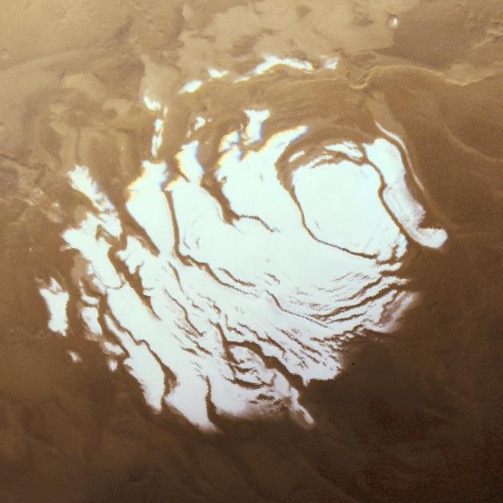
How does ‘swiss cheese’ form?

Image Credit:NASA/JPL-Caltech/Malin Space Science System
The curvy features that one sees in the image above are pits in the thin layer of CO2 ice that rests on top of permanent polar cap made up from a water ice and soil mix. The pits were first spotted at the carbon dioxide ice cap at the Martian south pole in 1999. They are a result of repeated cycles of condensation and sublimation of CO2: when thin layers of CO2 deposit even on a smooth surface, there inevitably will be some places that get a little more than their neighbors. This creates more and more irregularities every year year as the ice sublimes in the spring and summer and a new layer is deposited in the fall and winter. Each shadowed spot gets a bit less sunlight and accumulates more CO2; each exposed place gets a bit more exposed and loses more CO2. Eventually, pits form in the CO2 layer where more CO2 sublimates than condenses. The walls of the pits absorb even more sunlight, which makes them grow.
Craters in Polar Areas
We also ask you to identify if there are any craters in the image you’re reviewing. Typically craters on Mars look round or oval-shaped. At Mars' polar areas however they might look slightly distorted and asymmetric. This is because the underground in polar areas is rich with ice and – like glaciers for example – deforms the craters' rims and walls with time.

Image Credit:NASA/JPL-Caltech/Malin Space Science System
CTX and pointing HiRISE
The images you see on Planet Four: Terrains come from the Context Camera (shortened to CTX) orbiting Mars right now aboard NASA’s Mars Reconnaissance Orbiter (MRO).
As its name implies, CTX provides context for images acquired by other instruments onboard MRO. It creates images at 6 meters per pixel scale over a swath 30 kilometers wide. By comparison, High Resolution Imaging Science Experiment (HiRISE) images have a spatial scale of 0.25 meters per pixel and images are 6 kilometers wide. With CTX we can cover larger areas using the same data volume.
Often HiRISE and CTX take images simultaneously. The larger CTX image shows how the surface looks around the narrow high-resolution HiRISE strip. For scale, one can see the HiRISE footprint outlined in red in the example CTX image below:

CTX observation - Image Credit:NASA/JPL-Caltech/Malin Space Science System
The image below shows the HiRISE image that accompanied the the wide-area CTX observation above. HiRISE is the highest resolution camera ever sent to a planet, and . We will take HiRISE images of the most interesting features that you find in the CTX images to see what they look like in detail.

Higher resolution HIRISE observation - Image Credit: NASA/JPL/University of Arizona
Heritage: Planet Four
Planet Four: Terrains is a spinoff from the Zooniverse’s Planet Four project. In Planet Four we show images from HiRISE camera and we’ve asked all interested citizen scientists to mark the dark fans and blotches produced by the geysers and presence or absence of flowing wind. Many of our volunteers have noticed that those fans and blotches are often overlaying the strangest types of terrains mainly created by the repeated deposition and thawing of carbon dioxide ice. A big thank you to all of you who took the time to tell us about seeing these in Planet Four! The science team thought that now it is time to get more serious about studying them. So we have created this new project to identify and map them. The regions of interest identified by Planet Four: Terrains will eventually be featured on the original Planet Four project to search for fan and geyser activity in detail, and study how these regions evolve over time.