


The Bird ID workflow is temporarily paused while I update the field guide and make a few improvements to the classification choices based on volunteer feedback. The workflow should be back online no later than July 11 and ready for more classifications.
Thank you for all of your hard work. Please check back soon and watch for updates on the Announcements Talk Board, including the recent July 2026 Newsletter linked here. This newsletter talks about a few updates and important points on the Bird ID workflow.
Research
The Back Bay of Biloxi, Mississippi, is undergoing severe erosion, losing approximately one foot of land annually, thought to be driven by a high amount of boat wakes in the nearby channel. Mississippi State University’s Coastal Research and Extension Center in Biloxi, Mississippi received a grant from the National Fish and Wildlife Foundation to restore and protect 2.5-miles of shoreline in the Back Bay of Biloxi. This project will enhance coastlines in the Back Bay by marsh fill and sill, native species plantings, invasive species removal, and installation of segmented breakwaters. Coastal ecosystems are important to conserve because they protect coastlines, support fisheries, improve water quality, provide habitat for wildlife, and store carbon.

Above is an example of a living shoreline construction project that our organization carried out a few years ago. The rows of stacked cement blocks act as segmented breakwaters to protect the shoreline from strong waves and currents. As you can see, our team also planted several native marsh plant species. These plant species help keep sediment in place, prevent erosion, and provide habitat and food for wildlife. A similar living shoreline construction effort will be executed for this project.
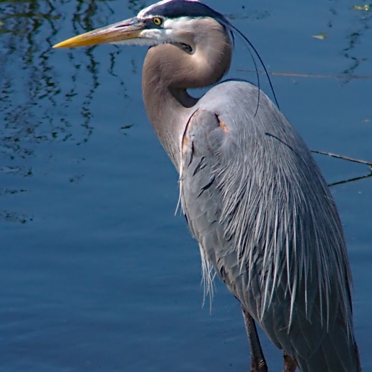
The grant that is funding this project requires bird monitoring, which will be conducted before and during the restoration process. For this project, a total of 16 game cameras have been installed across various shoreline types throughout the central portion of Biloxi Bay. These game cameras are monitoring baseline wildlife activity with a focus on birds.
A critical component of this project is to understand how birds utilize various shoreline environments, such as natural marsh areas, riprap, and breakwaters. Riprap is a layer of large stones that protects soil from erosion in areas of high water flow. Coastal erosion is the gradual loss of land along a shoreline due to waves, currents, tides, and other natural and human-caused processes. A breakwater is a rock and rubble mound structure built parallel to a shoreline. It shelters the shoreline from strong waves and currents.
Findings from this project will provide valuable insights into bird habitat usage and the effectiveness of living shorelines in restoring coastal habitats. Cameras collect an image every 5 minutes while deployed and will be deployed in 2 week increments at least 6 times per year. Imagery will be analyzed for bird abundance and diversity along different shoreline types with the help of citizen scientists through Zooniverse.
Volunteers are necessary for this project because of the sheer volume of photos associated with this project. There are tens of thousands of photos to sort through and the Mississippi State team can't sort through them alone. That is why we are using Zooniverse.
Thank you for considering helping with this project. You are helping to understanding bird behavior which will inform future habitat restoration projects. This data will be used by the project leader, Leslie Azwell, for her master's thesis. Leslie plans to use this data to write several publications. She also plans to share her findings at conferences across the state of Mississippi and the country.