


Please leave us your feedback using this short Google form: https://forms.gle/xN7FxawEwtX1DvJj8
Research
The Border

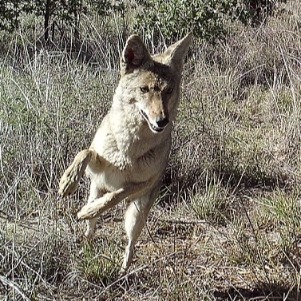
The Trump administration has waived dozens of federal laws to fast-track border wall construction, including the Endangered Species Act and National Environmental Protection Act – allowing 30-foot tall steel walls to be built in sensitive wildlife areas without any environmental evaluation or mitigation. The binational Border Wildlife Study fills this serious gap in environmental review by rigorously documenting border wildlife, including the installation of a camera array across 35 miles in Southern Arizona and Northern Sonora, Mexico. Capturing photos and video 24/7, the project generates tens of thousands of images weekly. We will monitor for change in the wildlife community over time, if, and when, the border wall cuts through this landscape. Our data will evaluate the wall’s environmental impact and guide the future protection and restoration of vital wildlife pathways.
The Camera Array

Our camera array has 60 camera trap points arranged in a grid along 34 miles of the border. Every camera is within 3 km of the border and 2 km from the closest adjacent camera in the study. Each passive infrared camera triggers when it senses motion and heat to capture images of wildlife 24 hours a day and 7 days a week.
This design creates a network of camera points optimized to detect both wide-ranging large mammals like jaguar and small animals like coati and birds. Our design is based on the global wildlife monitoring standard—TEAM Terrestrial Vertebrate Protocol (2011)—and it is used by the National Park Service, Parks Canada, and numerous wildlife biologists in ecosystems across the planet.
Counting Species Over Time
At every camera point and for the whole camera array collectively, we keep track of each new species as it is detected. With these data, we will create a species accumulation curve—scientist speak for how many species are detected over time. These data will provide evidence of wildlife occupancy at the border zone and the shape of this curve will also alert us to when we have likely detected a majority of the species each study area.
Project Goals
If we can continue the study post-border wall construction, then we will compare the future wildlife community with the one we are measuring today to learn how the wall impacts the number of species able to thrive in the borderlands bisected by wall. It all starts with learning what species live in this special place now. Without knowing who is there, we cannot possibly begin to design the conservation strategies to protect them.
How You can Help
Sorting through thousands of pictures and correctly identifying each species is challenging, so we need your eyes and mammal identification experience to help us identify and classify every image. Every classification you make will help us verify species identification that has been conducted by our staff and volunteers.

Read more about our Border Wildlife Study and our other conservation projects on the Sky Island Alliance Website