


All subjects for this study have now been counted!
Thank you to everyone who participated and counted penguins with us!
There may be more counting next season - we'll let you know!
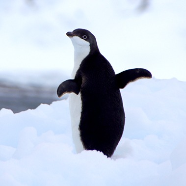
Help us find out how many Adélie penguins live on Ross Island in Antarctica!
Learn moreYou can do real research by clicking to get started here!
Zooniverse Talk
Chat with the research team and other volunteers!
Adélie penguins on Ross Island Statistics
View more statsAll Time Stats
Active Stats
Active stats provide information about currently active workflows and subjects.
Message from the researcher
Your support in building accurate and timely wildlife counts is critical to spotting population changes that will impact Antarctic conservation efforts. With your help this project could have real-world implications for Adélie penguins and the ecosystem.
Adélie penguins on Ross IslandAbout Adélie penguins on Ross Island
Adélie penguins (Pygoscelis adeliae) are considered a key biological indicator species in the Antarctic, in part due to how much they like to eat Antarctic krill (Euphausia superba), which is a tiny (and difficult to monitor) but very important species in the Southern Ocean. Through knowing how many Adélie penguins there are, scientists can get important insights into things such as the effectiveness of Marine Protected Areas (MPAs), the effects of environmental change, or the impacts of fisheries in the area.

Annotated image showing the location of Ross Island in Antarctica. Images used from Google Earth.
Adélie penguin numbers on Ross Island, Antarctica, are monitored each year by Antarctica New Zealand, in collaboration with Manaaki Whenua/Landcare Research, as part of the Commission for the Conservation of Antarctic Marine Living Resources (CCAMLR) Ecosystem Monitoring Program (CEMP). Photographs are taken from a helicopter during the Adélie penguin breeding season each year, covering the three colonies on Ross Island - Cape Bird, Cape Royds, and Cape Crozier.
The aim of this project is to identify the most accurate means of counting Adélie penguins. The most recent iteration of this project is looking specifically at the largest Ross Island colony – Cape Crozier. Historically there have been an estimated 300,000+ Adélie penguins breeding on Ross Island, so counting them all is a big job!
This project is being undertaken as part of a thesis being completed towards the requirements of the Master of Geospatial Data Science program at the University of Canterbury. In prior years the data contributed to Master of Antarctic Studies research.
Project background and avatar photographs provided by Ursula Rack.


Special thanks to Antarctica New Zealand and Manaaki Whenua/Landcare Research for their support of this project and for providing aerial imagery.