


Finished! Looks like this project is out of data at the moment!
Research
There are three main science aims for Gravity Wave Zoo:
- Identify gravity waves, instabilities, and breaking.
- Learn what conditions are needed for these different events to take place.
- Compile observations over multiple years to study seasonal variations in gravity wave events.
Gravity Wave Zoo plans on taking classified observations made by volunteers to do a long-term, seasonal study of the weather dynamics in the upper atmosphere that causes and supports these wave events. Video clips classified as having gravity waves and/or instabilities will then be analyzed using radar data and sodium LIDAR data to investigate the conditions that allowed waves to form. Using radar data will allow the team to measure the wind velocities associated with the wave activity, while sodium LIDAR data will allow us to measure the temperature differences as a function of altitude. This wealth of knowledge will help us determine how much energy and heat is being deposited into the atmosphere. We also intend to use classified data to create a machine-learning algorithm that can assist in classifying wave events.
We'll achieve those aims through Gravity Wave Zoo by using classifications to do bigger statistical studies than ever before. We're sure that citizen scientists will also find exciting and unusual events to study in more detail – things nobody has ever seen before.

Credit: Jorge Magalhaes and Jose da Silva (distributed via imaggeo.egu.eu)
How can gravity create waves?
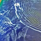
Most people are familiar with waves in the ocean. Waves occur when winds blow across the surface of the water, causing friction between the air and water's surface. The winds transport their energy and cause the water to move in a circular motion in the direction of the wind. As water molecules rise and fall, waves are created. But in fact, waves can occur in the atmosphere as well. For a gravity wave to start, something must trigger the air to be displaced vertically. An example of trigger mechanisms is mountains and updrafts from thunderstorms. To generate the wave, the air must be forced to rise up into stable air. Why must the air be stable? If the air is unstable, it will continue to rise and won't be able to form a wave pattern. When air rises into stable air, the stability of the environment will allow gravity to naturally pull the air back down over time. The momentum of the air keeps it moving forward, but the air continues to overshoot its equilibrium point. The parcel of air will try to remain at a location in the atmosphere where no forces are causing it to rise or sink. This results in a propagating oscillation which we perceive as a gravity wave!

Credit: Weather.gov
Why is this research important?
Some of the most powerful waves propagating through atmospheres are silent and invisible. These atmospheric waves are big, having wavelengths ranging from meters to thousands of kilometers. Their effects on a planet's climate system are tremendous and varied. The momentum transport by gravity waves is highly important to atmospheric circulation, structure, and variability, especially in the middle atmosphere (Lindzen, 1981). Gravity waves are also closely related to severe weather phenomena, such as downslope windstorms, orographic precipitation, and clear-air turbulence. There are many open questions regarding the fundamental dynamics of gravity waves, namely the origin of their formation, maintenance, propagation (i.e., ways in which waves travel), and breaking (i.e., the wave becomes unstable). When gravity waves break, they alter the atmospheric flow by depositing stored momentum and energy, leading to turbulent mixing (Fritts & Alexander, 2003). An additional area of importance is the interaction of gravity waves with atmospheric boundary layer processes. The atmospheric boundary layer is the region of the lower troposphere where Earth's surface strongly influences temperature, moisture, and wind through the turbulent transfer of air mass. Gravity waves are poorly resolved in global circulation models in the middle atmosphere (Medvedev and Yigit, 2019). They are not accounted for at all in models specific to the near-space environment in the thermosphere and ionosphere. Moreover, observations of gravity waves are critical for better constraining gravity wave drag parameterizations implemented in numerical weather prediction and climate models (Kim et al., 2003; Orr et al., 2010).
Gravity waves also have the potential to create significant impacts, especially in aviation.
Jack Williams, who is an instrument-rated private pilot and author of The AMS Weather Book: The Ultimate Guide to America’s Weather, shared the following story:
"Thunderstorms, like mountains, also create gravity waves as wind flows over them. One striking example occurred in June 1996, when Air Force One, with President Bill Clinton aboard, hit severe turbulence while flying 33,000 feet over the Texas Panhandle. Afterward, those eating in the press area said it looked like they had had a huge food fight. The investigation showed that wind blowing over a distant thunderstorm formed a gravity wave that shook Air Force One."
A gravity wave's effects on weather make it important to aviators. Lifting motions are maximized just ahead of the wave crest while sinking motions are maximized just ahead of the wave trough. How does this affect flying conditions? The updrafts and downdrafts would directly affect the vertical motion of the aircraft. Moderate to extreme turbulence could be expected. Often no clouds are associated with gravity waves themselves, so they can approach unannounced to pilots. By identifying instances of gravity wave events, we can form better models in both climate change and weather-forecasting applications. Furthermore, by improving forecasting techniques, meteorologists can make forecasts to warn pilots headed toward the weather.

Credit: www.nsf.gov
The Alaska Poker Flat Research Range houses the OH airglow imager used for collecting data. The imager resolves small-scale gravity waves, breaking, and instabilities near an altitude of 86 km. That is about 53.5 miles above the earth's surface. That's equivalent to stacking roughly 10 Mount Everests on top of each other! To put that into perspective, the typical cruising altitude for a commercial airplane is between 6 and 8 miles above sea level.
The imager uses a fisheye lens that gives a 180-degree view of the sky. We can see from horizon to horizon approximately 1,000,000 square km. The imager views the near-infrared emission from 900 to 1700 nm. Thousands of images are taken, and citizen scientists can classify events that have never been viewed before.

What is airglow, and how does it occur?
Airglow is the faint luminescence that occurs high in the atmosphere and is the result of various atoms, molecules, and ions that get excited (chemistry-excited, that is… not “woohoo!”-excited) by ultraviolet radiation from the Sun and then release that energy as visible – as well as infrared – light when they return to their “normal” state. It’s not entirely unlike glow-in-the-dark toys or paint! This light is most visible to astronauts on the ISS when it is orbiting over the night side of the planet and thus is seen in images like the one below. It appears like a thin band because viewing the atmosphere at a shallow angle – rather than directly down through it – increases the airglow layers' relative visibility.

Credit:NASA
Most of the visible airglow comes from oxygen atoms and molecules, which glow green, as commonly seen in the aurora. Other contributing elements include sodium atoms, molecular oxygen, and hydroxyl radicals (OH). Excited OH radicals emit in the infrared in a narrow layer centered at ~ 86-87 km. When we see gravity waves, we are actually witnessing the OH layer being displaced upwards and downwards.

What is OH, and where does it come from?
Hydroxyl (OH) is a hydrogen atom covalently bonded to an oxygen atom. The excited OH molecule radiates energy. A multitude of vibrational and rotational states in excited OH cascade to lower energy states by emitting light (photons). This results in an emission spectrum that extends over a wide wavelength range of 500 nm to 5,000 nm. It is strongest in bands in the infrared (1,600 nm and 2,800 nm). These are the brightest emissions in the night sky, but we can’t see them. They are beyond the visible spectrum range of 400 nm to 700 nm. However, our OH airglow imager can 'see' these emissions!

Credit: Antarctica.gov.au
References
Fritts, D. C. and Alexander, M. J. (2003). Gravity wave dynamics and effects in the middle atmosphere.
Reviews of geophysics, 41(1).
Kim, Y.-J., Eckermann, S. D., and Chun, H.-Y. (2003). An overview of the past, present and future of
gravity-wave drag parametrization for numerical climate and weather prediction models. Atmosphere-
Ocean, 41(1):65–98.
Lindzen, R. S. (1981). Turbulence and stress owing to gravity wave and tidal breakdown. Journal of
Geophysical Research: Oceans, 86(C10):9707–9714.
Medvedev, A. S. and Yi ̆git, E. (2019). Gravity waves in planetary atmospheres: Their effects and
parameterization in global circulation models. Atmosphere, 10(9):531.
Orr, A., Bechtold, P., Scinocca, J., Ern, M., and Janiskova, M. (2010). Improved middle atmosphere
climate and forecasts in the ecmwf model through a nonorographic gravity wave drag parameterization.
Journal of climate, 23(22):5905–5926.