


This project has been built using the Zooniverse Project Builder but is not yet an official Zooniverse project. Queries and issues relating to this project directed at the Zooniverse Team may not receive any response.
Help conservationists monitor waterholes using satellite imagery, to help protect wildlife in Cambodia and Namibia.
Learn moreHelp us identify waterholes and surrounding forest clearing in Cambodia.
Zooniverse Talk
Chat with the research team and other volunteers!
Wildlife Waterholes Statistics
View more statsAll Time Stats
Active Stats
Active stats provide information about currently active workflows and subjects.
Message from the researcher
Connect with the research team on Talk to learn more about this project!
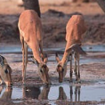
About Wildlife Waterholes
In this project we ask you to help us to identify waterholes in key conservation areas in Cambodia and Namibia for wildlife monitoring and conservation purposes. The project uses high resolution Earth Observation satellite imagery from the European Space Agency and Urthecast, and is a partnership between WWF and Imperative Space.
Identifying the location, size and persistence of waterholes helps scientists and WWF conservationists to predict important animal migrations and take steps to protect populations. This information can also be used to help counter illegal illegal poaching activity, as poachers often target waterholes because of their abundance of wildlife.
This project is a part of the ESA Crowd4Sat initiative.


